A CRITICAL ATLAS OF THE GRAND PARIS

PROJECT a series of maps that critically examines the contested master plan to expand Paris beyond its current city boundaries, drawing on various mapmaking traditions and modes of representation to explore the emotional, social, and financial dimensions of the production of space.
LOCATION Paris, France and New York City, NY
ADVISOR Shannon Mattern | Maps as Media, The New School
INTRODUCTION
The banlieues around Paris - the often ill-regarded suburbs severed off from the City of Lights by a multi-lane ring road - have long captured the imaginary of the media, policymakers, architects, urban planners, filmmakers, and increasingly, real estate developers. Taking the nature of this contested territory as a starting point, A Critical Atlas of the Grand Paris explores the historical, financial, power, racial, class, and emotional dimensions at play in the current territorial expansion of Paris beyond its city walls. Drawing on principles of deep mapping, feminist geography, and counter-cartography, I experimented across media, modes of representation, and cartographic languages to create a series of maps that critically examine the making of “the Grand Paris” through a range of angles and representations. This process allowed me to reflect on my practice as a cartographer and to produce a short manifesto, featured below.
Table of Contents: Map Themes & Titles
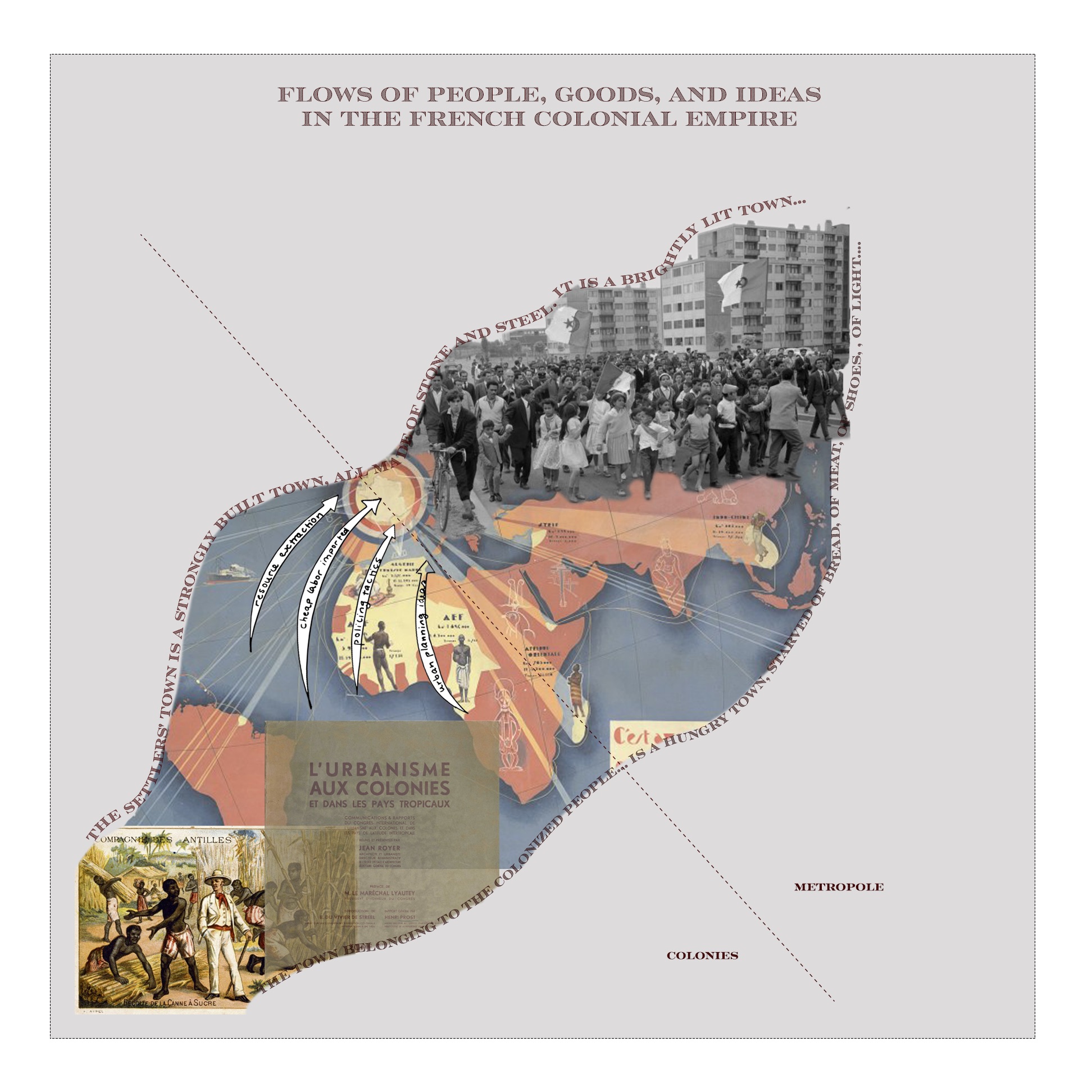
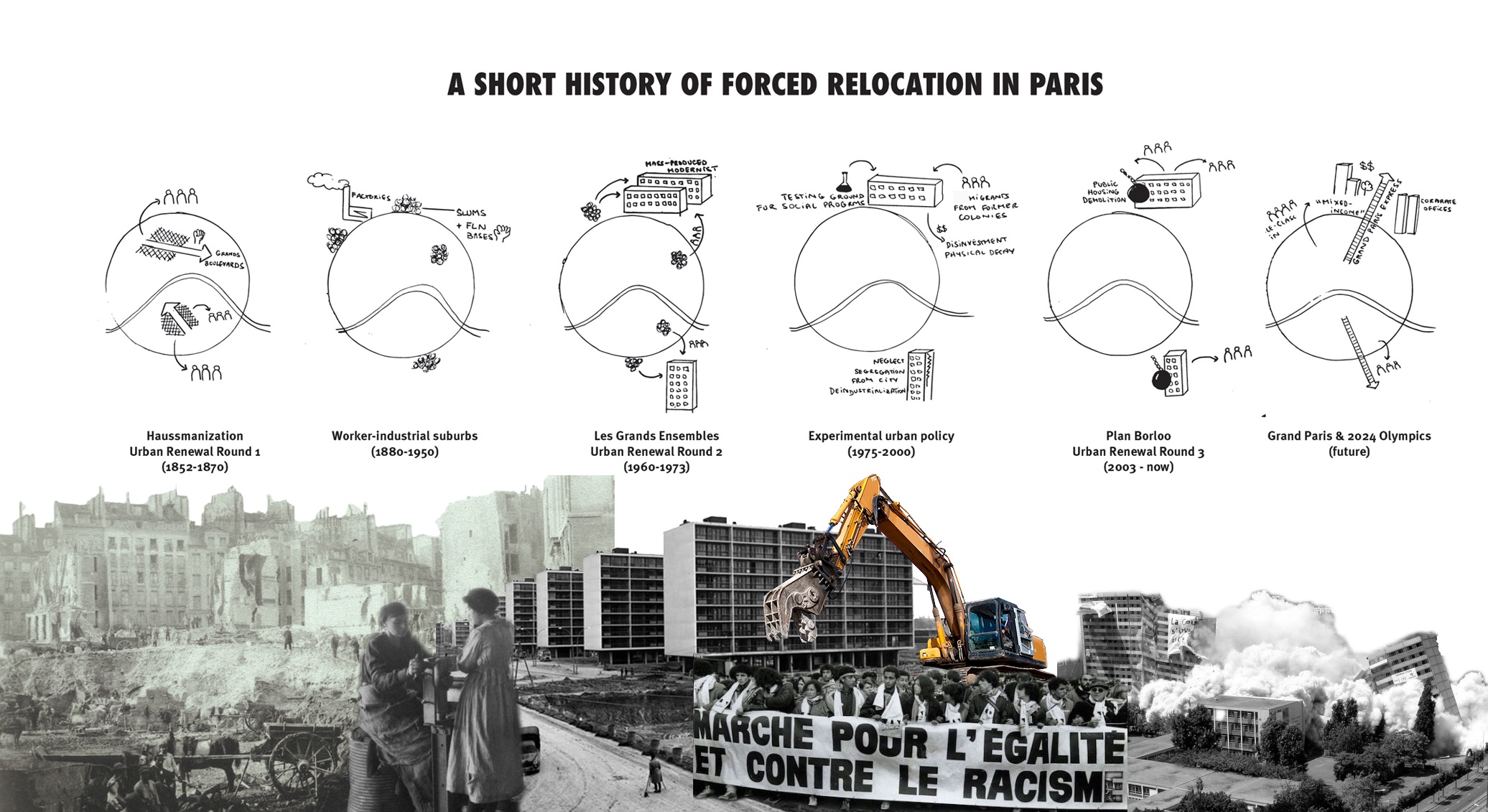
Unraveling History: A Short History of Forced Relocation in Paris and Flows of People, Goods, and Ideas in the French Colonial Empire
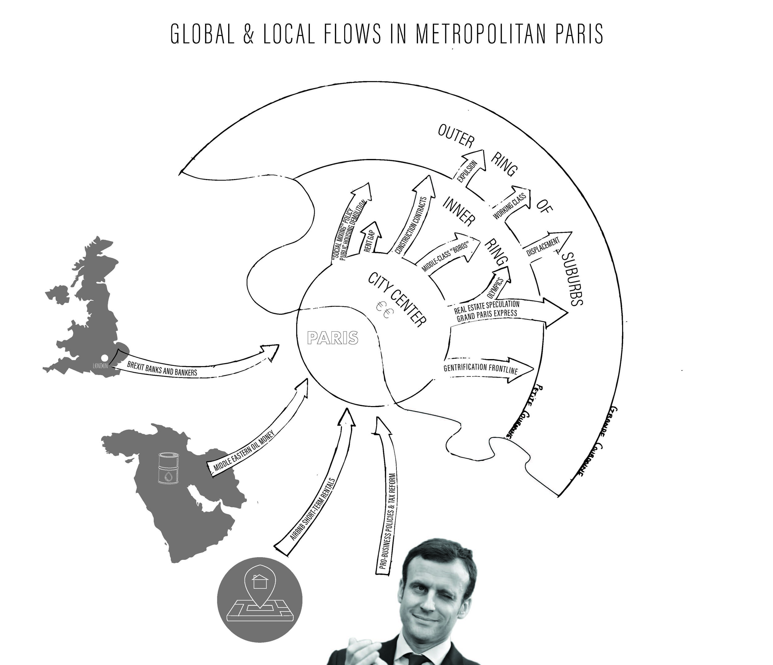
Mapping the Invisible: Global & Local Flows in Metropolitan Paris
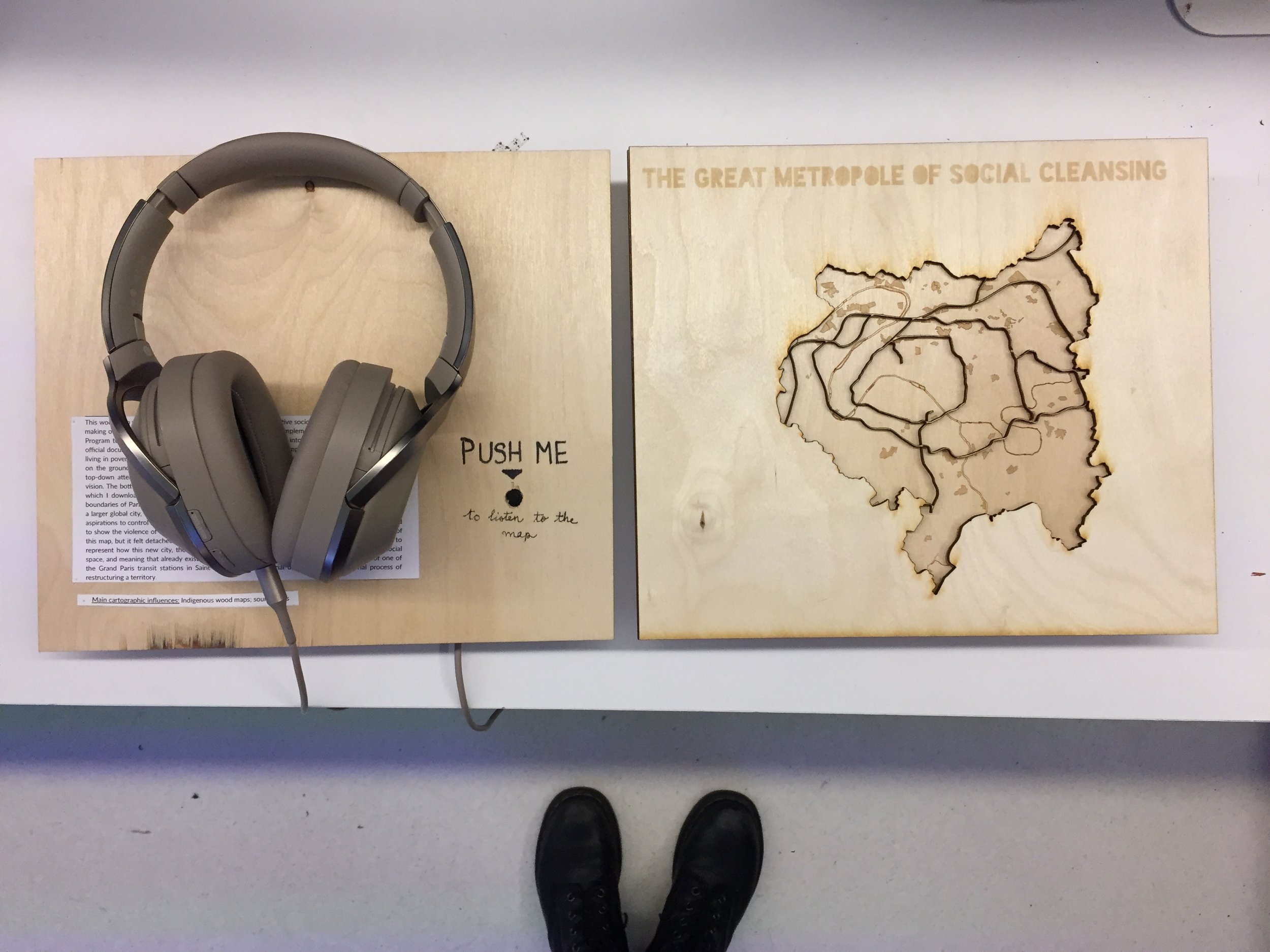
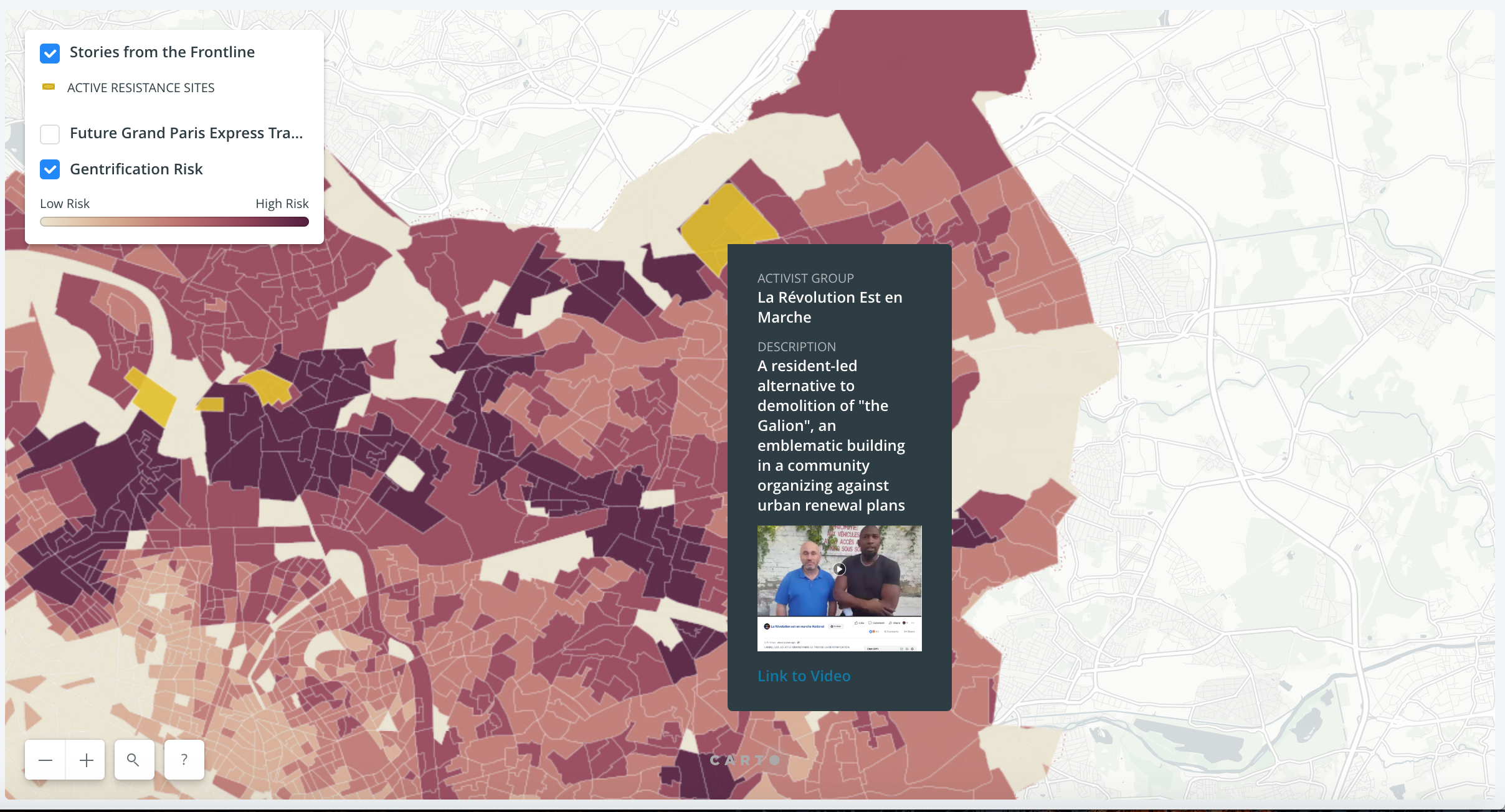
Sensorial Mapping: The Great Metropole of Social Cleansing
Mapping Resistance: Barricade Map of the Grand Paris [Prototype]
Participatory Mapping: Designing a Collective Mapmaking Processes
Mapping as a Critical Practice
Maps are not merely the product of scientific knowledge, nor a straightforward visualization of geographic data. They are never neutral objects of knowledge, rather, they are “sites of power and produce worlds that are intimately bound up with that power”. Critical literature abounds on the map as a tool for colonial domination and resource extraction, as a militaristic technology of surveillance, as a mechanism for rationalizing and commodifying landscape, as an expression of the totalizing gaze of the State over a territory to control and discipline land and labor. With the growing accessibility of Geographic Information Systems (GIS) and the proliferation of open data portals, it has become ever so easy to download a geographic dataset of far-flung places and to represent them from the distant, emotionless perspective of the “god’s eye view from nowhere,” or the “god-trick’”. Without a careful critique of the limitations of these spatial epistemologies and the power relations that produce them, GIS can lock us into a cartesian space with an X & Y coordinate and perpetuate processes of epistemic violence by imposing one mode of representation while casting other forms of knowing the world as obsolete or not “scientific.” As a cartographer and an urbanist trained in GIS software, it is particularly critical for me to remember that maps can also “create territory,” became self-fulfilling prophecies once a place has been designated as dangerous and worthless or as profitable and exploitable.
How, then, can we reclaim maps and mapping as an act, as a subjective and embodied practice, as a pedagogical device, as a narrative tool, as a decolonial research method, as a critical and radical affirmation? Drawing on principles of deep mapping, feminist geography, and critical cartography, I have experimented across media, modes of representation, and cartographic languages to explore the making of the Grand Paris through a range of angles, generating what I hope is a collection of “multimodal,” “multivocal,” and “multilayered” maps. Working across geographic scales and historical layers, I have used hand-drawn sketches, archival materials, collaging, digital maps, material maps, GIS software, and sound recordings to represent my topic of inquiry through time, space, relations of power, globally networked flows, and subjective reflections on the making of urban space. As an urbanist, I read the city as a palimpsest of layers sedimented in place, and as a socially produced space carved out by relations of power, everyday experiences of inhabitants, and practices of resistance. Maps are a tool for me to represent space not as static or neutral but as co-produced, contested, and constantly being reshaped and as a way make sense of complex urban situations in a visual, shareable way. By drawing on different cartographic traditions and aesthetic sensitivities, I hope to reveal another layer of interpretation through each representational method, to validate multiple forms of knowledge, and to reclaim mapping as a capacious, inclusive practice.